Agricultural census data for the Island of Ireland#
import os
import matplotlib.pyplot as plt
import pandas as pd
import geopandas as gpd
ROI data#
bound_ie = gpd.read_file(
    os.path.join("data", "boundaries", "boundaries_all.gpkg"),
    layer="OSi_IE_electoral_divisions_2019",
)
bound_ie.head()
| ED_ID | ENGLISH | GAEILGE | CONTAE | COUNTY | PROVINCE | GUID | CENTROID_X | CENTROID_Y | AREA | ESRI_OID | Shape__Are | Shape__Len | geometry | |
|---|---|---|---|---|---|---|---|---|---|---|---|---|---|---|
| 0 | 267160 | TURNAPIN | Turnapain | Baile Átha Cliath | DUBLIN | Leinster | 2ae19629-1cea-13a3-e055-000000000001 | 717365.57 | 740807.88 | 943505.13 | 1 | 9.435051e+05 | 4732.251966 | POLYGON ((717716.712 741601.510, 717759.461 74... |
| 1 | 27045 | DRUMLUMMAN | Droim Lomáin | An Cabhán | CAVAN | Ulster | 2ae19629-1caa-13a3-e055-000000000001 | 638130.82 | 789588.69 | 17617760.82 | 2 | 1.761776e+07 | 21762.101454 | POLYGON ((637756.185 787640.988, 637753.646 78... |
| 2 | 117019 | CASTLEFORE | Baile Choille Fóir | Liatroim | LEITRIM | Connacht | 2ae19629-171c-13a3-e055-000000000001 | 606853.02 | 809670.32 | 14080012.63 | 3 | 1.408001e+07 | 21907.071044 | POLYGON ((608196.069 807618.950, 608244.536 80... |
| 3 | 37135 | RAHONA | Ráth Úna | An Clár | CLARE | Munster | 2ae19629-1fec-13a3-e055-000000000001 | 481634.87 | 649839.86 | 24664562.56 | 4 | 2.466456e+07 | 35830.867808 | POLYGON ((484212.068 651795.629, 484231.866 65... |
| 4 | 167021 | CROSSAKEEL | Crosa Caoil | An Mhí | MEATH | Leinster | 2ae19629-1861-13a3-e055-000000000001 | 662161.01 | 774125.96 | 20159197.51 | 5 | 2.015920e+07 | 34415.329703 | POLYGON ((663308.409 776111.796, 663305.294 77... |
bound_ie.shape
(3455, 14)
coa_ie = pd.read_csv(
    os.path.join("data", "agricultural_census", "CSO", "COA_2020.csv")
)
coa_ie.head()
| C03904V04656 | electoral_division | total_cattle | total_sheep | total_grass_hectares | |
|---|---|---|---|---|---|
| 0 | 3576C59993454152E0530100007F0280 | Brisha / Capard, Co.Laois, 08045/08046 | 1955 | 420 | 964.3 |
| 1 | 3576C59992AD4152E0530100007F0280 | Firry / Newgrove, Co.Longford, 09024/09035 | 2164 | 675 | 965.4 |
| 2 | 2AE1962918C813A3E055000000000001 | Fair Gate, Co.Louth, 10001 | 0 | 0 | 0.0 |
| 3 | 2AE19629193513A3E055000000000001 | St. Laurence Gate, Co.Louth, 10002 | 0 | 0 | 0.0 |
| 4 | 2AE19629191E13A3E055000000000001 | West Gate, Co.Louth, 10003 | 0 | 0 | 0.0 |
coa_ie.shape
(3409, 5)
bound_ie["C03904V04656"] = (
    bound_ie["GUID"].replace("-", "", regex=True).str.upper()
)
bound_ie.head()
| ED_ID | ENGLISH | GAEILGE | CONTAE | COUNTY | PROVINCE | GUID | CENTROID_X | CENTROID_Y | AREA | ESRI_OID | Shape__Are | Shape__Len | geometry | C03904V04656 | |
|---|---|---|---|---|---|---|---|---|---|---|---|---|---|---|---|
| 0 | 267160 | TURNAPIN | Turnapain | Baile Átha Cliath | DUBLIN | Leinster | 2ae19629-1cea-13a3-e055-000000000001 | 717365.57 | 740807.88 | 943505.13 | 1 | 9.435051e+05 | 4732.251966 | POLYGON ((717716.712 741601.510, 717759.461 74... | 2AE196291CEA13A3E055000000000001 |
| 1 | 27045 | DRUMLUMMAN | Droim Lomáin | An Cabhán | CAVAN | Ulster | 2ae19629-1caa-13a3-e055-000000000001 | 638130.82 | 789588.69 | 17617760.82 | 2 | 1.761776e+07 | 21762.101454 | POLYGON ((637756.185 787640.988, 637753.646 78... | 2AE196291CAA13A3E055000000000001 |
| 2 | 117019 | CASTLEFORE | Baile Choille Fóir | Liatroim | LEITRIM | Connacht | 2ae19629-171c-13a3-e055-000000000001 | 606853.02 | 809670.32 | 14080012.63 | 3 | 1.408001e+07 | 21907.071044 | POLYGON ((608196.069 807618.950, 608244.536 80... | 2AE19629171C13A3E055000000000001 |
| 3 | 37135 | RAHONA | Ráth Úna | An Clár | CLARE | Munster | 2ae19629-1fec-13a3-e055-000000000001 | 481634.87 | 649839.86 | 24664562.56 | 4 | 2.466456e+07 | 35830.867808 | POLYGON ((484212.068 651795.629, 484231.866 65... | 2AE196291FEC13A3E055000000000001 |
| 4 | 167021 | CROSSAKEEL | Crosa Caoil | An Mhí | MEATH | Leinster | 2ae19629-1861-13a3-e055-000000000001 | 662161.01 | 774125.96 | 20159197.51 | 5 | 2.015920e+07 | 34415.329703 | POLYGON ((663308.409 776111.796, 663305.294 77... | 2AE19629186113A3E055000000000001 |
# merge boundaries and census data
data_ie = pd.merge(bound_ie, coa_ie, on="C03904V04656", how="outer")
data_ie.shape
(3487, 19)
# find data rows without a geometry
data_na = data_ie[data_ie["geometry"].isnull()][
    [
        "C03904V04656",
        "electoral_division",
        "total_cattle",
        "total_sheep",
        "total_grass_hectares",
    ]
]
data_na
| C03904V04656 | electoral_division | total_cattle | total_sheep | total_grass_hectares | |
|---|---|---|---|---|---|
| 3455 | 3576C59993454152E0530100007F0280 | Brisha / Capard, Co.Laois, 08045/08046 | 1955.0 | 420.0 | 964.3 |
| 3456 | 3576C59992AD4152E0530100007F0280 | Firry / Newgrove, Co.Longford, 09024/09035 | 2164.0 | 675.0 | 965.4 |
| 3457 | 3576C59993334152E0530100007F0280 | Esker / Ballaghassaan, Co.Offaly, 12043/12034 | 3830.0 | 923.0 | 1792.4 |
| 3458 | 3576C599940F4152E0530100007F0280 | Ballinalack / Lackan, Co.Westmeath, 13054/13085 | 2685.0 | 2311.0 | 1748.1 |
| 3459 | 3576C59994FC4152E0530100007F0280 | Noughaval / Castletown, Co.Clare, 16014/16008 | 4311.0 | 940.0 | 4445.3 |
| 3460 | 3576C59994AA4152E0530100007F0280 | Glenroe / Ballyeighter, Co.Clare, 16020/16017 | 2379.0 | 808.0 | 2450.5 |
| 3461 | 3576C59996354152E0530100007F0280 | Corlea / Cahermurphy, Co.Clare, 16128/16123 | 689.0 | 0.0 | 1051.5 |
| 3462 | 3576C59995BD4152E0530100007F0280 | Inishcaltra North / Inishcaltra South, Co.Clar... | 2114.0 | 0.0 | 1094.7 |
| 3463 | 3576C599953E4152E0530100007F0280 | Bantry Rural / Whiddy, Co.Cork, 18033/18046 | 3387.0 | 2596.0 | 2411.1 |
| 3464 | 3576C59996CB4152E0530100007F0280 | Ceannúigh / Máistir Gaoithe, Co.Kerry, 19009/1... | 1579.0 | 7615.0 | 4068.3 |
| 3465 | 3576C599971F4152E0530100007F0280 | Doire Ianna / Cloon, Co.Kerry, 19014/19011 | 1045.0 | 21522.0 | 7209.8 |
| 3466 | 3576C59998334152E0530100007F0280 | Greenhall / Lackagh, Co.Tipperary, 22037/22045 | 2385.0 | 1159.0 | 1750.6 |
| 3467 | 3576C59999824152E0530100007F0280 | Kilsheelan / Killaloan, Co.Tipperary, 23137/23136 | 3739.0 | 359.0 | 1728.7 |
| 3468 | 3576C59997034152E0530100007F0280 | Ballybeg South / Ballynaneashagh, Co.Waterford... | 0.0 | 0.0 | 0.0 |
| 3469 | 3576C59999FD4152E0530100007F0280 | Derrycunlagh / Derrylea, Co.Galway, 27027/27028 | 518.0 | 5186.0 | 3120.8 |
| 3470 | 3576C5999B294152E0530100007F0280 | Marblehill / Loughatorick, Co.Galway, 27129/27126 | 1597.0 | 393.0 | 1719.3 |
| 3471 | 3576C5999B084152E0530100007F0280 | Greaghglass / Stralongford, Co.Leitrim, 28007/... | 880.0 | 3391.0 | 1690.7 |
| 3472 | 3576C5999AA84152E0530100007F0280 | Drumreilly West / Drumreilly East, Co.Leitrim,... | 766.0 | 5527.0 | 1905.9 |
| 3473 | 3576C5999AEA4152E0530100007F0280 | Aghalateeve / Aghanlish, Co.Leitrim, 28027/28028 | 274.0 | 10020.0 | 1944.0 |
| 3474 | 3576C5999AEB4152E0530100007F0280 | Aghavoghill / Melvin, Co.Leitrim, 28029/28032 | 480.0 | 7953.0 | 1761.0 |
| 3475 | 3576C5999B174152E0530100007F0280 | Garvagh / Arigna, Co.Leitrim, 28041/28034 | 408.0 | 1882.0 | 950.9 |
| 3476 | 3576C5999AEE4152E0530100007F0280 | Glenco / Sheskin, Co.Mayo, 29058/29065 | 646.0 | 8044.0 | 3702.6 |
| 3477 | 3576C5999BB44152E0530100007F0280 | Owennadornaun / Bundorragha, Co.Mayo, 29150/29130 | 181.0 | 10308.0 | 1234.6 |
| 3478 | 3576C5999B404152E0530100007F0280 | Lisgarve / Mantua, Co.Roscommon, 30046/30048 | 2714.0 | 1296.0 | 1859.9 |
| 3479 | 3576C5999B934152E0530100007F0280 | Lough Allen / Altagowlan, Co.Roscommon, 30047/... | 424.0 | 1537.0 | 892.9 |
| 3480 | 3576C5999C054152E0530100007F0280 | Templeboy South / Mullagheruse, Co.Sligo, 3103... | 1211.0 | 8563.0 | 3810.5 |
| 3481 | 3576C5999C464152E0530100007F0280 | Branchfield / Carrownaskeagh, Co.Sligo, 31067/... | 806.0 | 4551.0 | 1568.1 |
| 3482 | 3576C5999C144152E0530100007F0280 | Loughill / Cloonacool, Co.Sligo, 31078/31071 | 737.0 | 10066.0 | 3307.2 |
| 3483 | 3576C5999C884152E0530100007F0280 | Pedara Vohers / Tircahan, Co.Cavan, 32025/32028 | 940.0 | 2752.0 | 1531.2 |
| 3484 | 3576C59999EE4152E0530100007F0280 | Templeport / Benbrack, Co.Cavan, 32027/32018 | 1146.0 | 3741.0 | 1843.6 |
| 3485 | 3576C5999CF04152E0530100007F0280 | Dunmakeever / Derrynananta, Co.Cavan, 32084/32082 | 833.0 | 11142.0 | 2750.4 |
| 3486 | 3576C5999C9C4152E0530100007F0280 | Killinagh / Teebane, Co.Cavan, 32086/32087 | 422.0 | 3844.0 | 1424.1 |
data_na.shape
(32, 5)
# manual merging
data_na_left = data_na.copy()
data_na_right = data_na.copy()
data_na_left["ENGLISH"] = data_na_left["electoral_division"].str.split(
    expand=True, pat=" / "
)[0]
data_na_left["COUNTY"] = (
    data_na_left["electoral_division"]
    .str.split(expand=True, pat=" / ")[1]
    .str.split(expand=True, pat=",")[1]
    .str.split(expand=True, pat=" Co.")
)[1]
data_na_left.head()
| C03904V04656 | electoral_division | total_cattle | total_sheep | total_grass_hectares | ENGLISH | COUNTY | |
|---|---|---|---|---|---|---|---|
| 3455 | 3576C59993454152E0530100007F0280 | Brisha / Capard, Co.Laois, 08045/08046 | 1955.0 | 420.0 | 964.3 | Brisha | Laois |
| 3456 | 3576C59992AD4152E0530100007F0280 | Firry / Newgrove, Co.Longford, 09024/09035 | 2164.0 | 675.0 | 965.4 | Firry | Longford |
| 3457 | 3576C59993334152E0530100007F0280 | Esker / Ballaghassaan, Co.Offaly, 12043/12034 | 3830.0 | 923.0 | 1792.4 | Esker | Offaly |
| 3458 | 3576C599940F4152E0530100007F0280 | Ballinalack / Lackan, Co.Westmeath, 13054/13085 | 2685.0 | 2311.0 | 1748.1 | Ballinalack | Westmeath |
| 3459 | 3576C59994FC4152E0530100007F0280 | Noughaval / Castletown, Co.Clare, 16014/16008 | 4311.0 | 940.0 | 4445.3 | Noughaval | Clare |
data_na_right["ENGLISH"] = (
    data_na_right["electoral_division"]
    .str.split(expand=True, pat="/")[1]
    .str.split(expand=True, pat=", ")[0]
)
data_na_right["COUNTY"] = (
    data_na_right["electoral_division"]
    .str.split(expand=True, pat=" / ")[1]
    .str.split(expand=True, pat=",")[1]
    .str.split(expand=True, pat=" Co.")
)[1]
data_na_right.head()
| C03904V04656 | electoral_division | total_cattle | total_sheep | total_grass_hectares | ENGLISH | COUNTY | |
|---|---|---|---|---|---|---|---|
| 3455 | 3576C59993454152E0530100007F0280 | Brisha / Capard, Co.Laois, 08045/08046 | 1955.0 | 420.0 | 964.3 | Capard | Laois |
| 3456 | 3576C59992AD4152E0530100007F0280 | Firry / Newgrove, Co.Longford, 09024/09035 | 2164.0 | 675.0 | 965.4 | Newgrove | Longford |
| 3457 | 3576C59993334152E0530100007F0280 | Esker / Ballaghassaan, Co.Offaly, 12043/12034 | 3830.0 | 923.0 | 1792.4 | Ballaghassaan | Offaly |
| 3458 | 3576C599940F4152E0530100007F0280 | Ballinalack / Lackan, Co.Westmeath, 13054/13085 | 2685.0 | 2311.0 | 1748.1 | Lackan | Westmeath |
| 3459 | 3576C59994FC4152E0530100007F0280 | Noughaval / Castletown, Co.Clare, 16014/16008 | 4311.0 | 940.0 | 4445.3 | Castletown | Clare |
data_na = pd.concat([data_na_left, data_na_right])
data_na.shape
(64, 7)
# strip whitespace
data_na["ENGLISH"] = data_na["ENGLISH"].str.upper().str.strip()
data_na["COUNTY"] = data_na["COUNTY"].str.upper().str.strip()
data_na.head()
| C03904V04656 | electoral_division | total_cattle | total_sheep | total_grass_hectares | ENGLISH | COUNTY | |
|---|---|---|---|---|---|---|---|
| 3455 | 3576C59993454152E0530100007F0280 | Brisha / Capard, Co.Laois, 08045/08046 | 1955.0 | 420.0 | 964.3 | BRISHA | LAOIS |
| 3456 | 3576C59992AD4152E0530100007F0280 | Firry / Newgrove, Co.Longford, 09024/09035 | 2164.0 | 675.0 | 965.4 | FIRRY | LONGFORD |
| 3457 | 3576C59993334152E0530100007F0280 | Esker / Ballaghassaan, Co.Offaly, 12043/12034 | 3830.0 | 923.0 | 1792.4 | ESKER | OFFALY |
| 3458 | 3576C599940F4152E0530100007F0280 | Ballinalack / Lackan, Co.Westmeath, 13054/13085 | 2685.0 | 2311.0 | 1748.1 | BALLINALACK | WESTMEATH |
| 3459 | 3576C59994FC4152E0530100007F0280 | Noughaval / Castletown, Co.Clare, 16014/16008 | 4311.0 | 940.0 | 4445.3 | NOUGHAVAL | CLARE |
# manually change names to English
names = {
    "CEANNÚIGH": "CANUIG",
    "DOIRE IANNA": "DERRIANA",
    "AGHAVOGHILL": "AGHAVOGHIL",
    "LOUGHILL": "LOUGHIL",
    "MÁISTIR GAOITHE": "MASTERGEEHY",
}
data_na.replace({"ENGLISH": names}, inplace=True)
# drop these entries from the original dataframe
coa_ie = coa_ie[~coa_ie["C03904V04656"].isin(list(data_na["C03904V04656"]))]
coa_ie.shape
(3377, 5)
# merge boundaries and census data again
data_ie = pd.merge(bound_ie, coa_ie, on="C03904V04656", how="outer")
data_ie.shape
(3455, 19)
data_ie = pd.merge(data_ie, data_na, how="outer", on=["ENGLISH", "COUNTY"])
data_ie.head()
| ED_ID | ENGLISH | GAEILGE | CONTAE | COUNTY | PROVINCE | GUID | CENTROID_X | CENTROID_Y | AREA | ... | C03904V04656_x | electoral_division_x | total_cattle_x | total_sheep_x | total_grass_hectares_x | C03904V04656_y | electoral_division_y | total_cattle_y | total_sheep_y | total_grass_hectares_y | |
|---|---|---|---|---|---|---|---|---|---|---|---|---|---|---|---|---|---|---|---|---|---|
| 0 | 267160 | TURNAPIN | Turnapain | Baile Átha Cliath | DUBLIN | Leinster | 2ae19629-1cea-13a3-e055-000000000001 | 717365.57 | 740807.88 | 943505.13 | ... | 2AE196291CEA13A3E055000000000001 | Turnapin, Co.Dublin, 04042 | 0.0 | 0.0 | 0.0 | NaN | NaN | NaN | NaN | NaN |
| 1 | 27045 | DRUMLUMMAN | Droim Lomáin | An Cabhán | CAVAN | Ulster | 2ae19629-1caa-13a3-e055-000000000001 | 638130.82 | 789588.69 | 17617760.82 | ... | 2AE196291CAA13A3E055000000000001 | Drumlumman, Co.Cavan, 32089 | 2673.0 | 231.0 | 1249.1 | NaN | NaN | NaN | NaN | NaN |
| 2 | 117019 | CASTLEFORE | Baile Choille Fóir | Liatroim | LEITRIM | Connacht | 2ae19629-171c-13a3-e055-000000000001 | 606853.02 | 809670.32 | 14080012.63 | ... | 2AE19629171C13A3E055000000000001 | Castlefore, Co.Leitrim, 28063 | 630.0 | 0.0 | 805.9 | NaN | NaN | NaN | NaN | NaN |
| 3 | 37135 | RAHONA | Ráth Úna | An Clár | CLARE | Munster | 2ae19629-1fec-13a3-e055-000000000001 | 481634.87 | 649839.86 | 24664562.56 | ... | 2AE196291FEC13A3E055000000000001 | Rahona, Co.Clare, 16101 | 2369.0 | 0.0 | 1349.9 | NaN | NaN | NaN | NaN | NaN |
| 4 | 167021 | CROSSAKEEL | Crosa Caoil | An Mhí | MEATH | Leinster | 2ae19629-1861-13a3-e055-000000000001 | 662161.01 | 774125.96 | 20159197.51 | ... | 2AE19629186113A3E055000000000001 | Crossakeel, Co.Meath, 11061 | 4826.0 | 671.0 | 2014.1 | NaN | NaN | NaN | NaN | NaN |
5 rows × 24 columns
# finishing merges
data_ie.fillna(0, inplace=True)
data_ie["total_cattle"] = data_ie["total_cattle_x"] + data_ie["total_cattle_y"]
data_ie["total_sheep"] = data_ie["total_sheep_x"] + data_ie["total_sheep_y"]
data_ie["total_grass_hectares"] = (
    data_ie["total_grass_hectares_x"] + data_ie["total_grass_hectares_y"]
)
data_ie.replace({"electoral_division_x": {0.0: ""}}, inplace=True)
data_ie.replace({"electoral_division_y": {0.0: ""}}, inplace=True)
data_ie["electoral_division"] = data_ie["electoral_division_x"].astype(
    str
) + data_ie["electoral_division_y"].astype(str)
# drop unnecessary columns
data_ie.drop(
    columns=[
        "C03904V04656_x",
        "electoral_division_x",
        "total_cattle_x",
        "total_sheep_x",
        "total_grass_hectares_x",
        "C03904V04656_y",
        "electoral_division_y",
        "total_cattle_y",
        "total_sheep_y",
        "total_grass_hectares_y",
    ],
    inplace=True,
)
data_ie.head()
| ED_ID | ENGLISH | GAEILGE | CONTAE | COUNTY | PROVINCE | GUID | CENTROID_X | CENTROID_Y | AREA | ESRI_OID | Shape__Are | Shape__Len | geometry | total_cattle | total_sheep | total_grass_hectares | electoral_division | |
|---|---|---|---|---|---|---|---|---|---|---|---|---|---|---|---|---|---|---|
| 0 | 267160 | TURNAPIN | Turnapain | Baile Átha Cliath | DUBLIN | Leinster | 2ae19629-1cea-13a3-e055-000000000001 | 717365.57 | 740807.88 | 943505.13 | 1 | 9.435051e+05 | 4732.251966 | POLYGON ((717716.712 741601.510, 717759.461 74... | 0.0 | 0.0 | 0.0 | Turnapin, Co.Dublin, 04042 |
| 1 | 27045 | DRUMLUMMAN | Droim Lomáin | An Cabhán | CAVAN | Ulster | 2ae19629-1caa-13a3-e055-000000000001 | 638130.82 | 789588.69 | 17617760.82 | 2 | 1.761776e+07 | 21762.101454 | POLYGON ((637756.185 787640.988, 637753.646 78... | 2673.0 | 231.0 | 1249.1 | Drumlumman, Co.Cavan, 32089 |
| 2 | 117019 | CASTLEFORE | Baile Choille Fóir | Liatroim | LEITRIM | Connacht | 2ae19629-171c-13a3-e055-000000000001 | 606853.02 | 809670.32 | 14080012.63 | 3 | 1.408001e+07 | 21907.071044 | POLYGON ((608196.069 807618.950, 608244.536 80... | 630.0 | 0.0 | 805.9 | Castlefore, Co.Leitrim, 28063 |
| 3 | 37135 | RAHONA | Ráth Úna | An Clár | CLARE | Munster | 2ae19629-1fec-13a3-e055-000000000001 | 481634.87 | 649839.86 | 24664562.56 | 4 | 2.466456e+07 | 35830.867808 | POLYGON ((484212.068 651795.629, 484231.866 65... | 2369.0 | 0.0 | 1349.9 | Rahona, Co.Clare, 16101 |
| 4 | 167021 | CROSSAKEEL | Crosa Caoil | An Mhí | MEATH | Leinster | 2ae19629-1861-13a3-e055-000000000001 | 662161.01 | 774125.96 | 20159197.51 | 5 | 2.015920e+07 | 34415.329703 | POLYGON ((663308.409 776111.796, 663305.294 77... | 4826.0 | 671.0 | 2014.1 | Crossakeel, Co.Meath, 11061 |
data_ie.shape
(3455, 18)
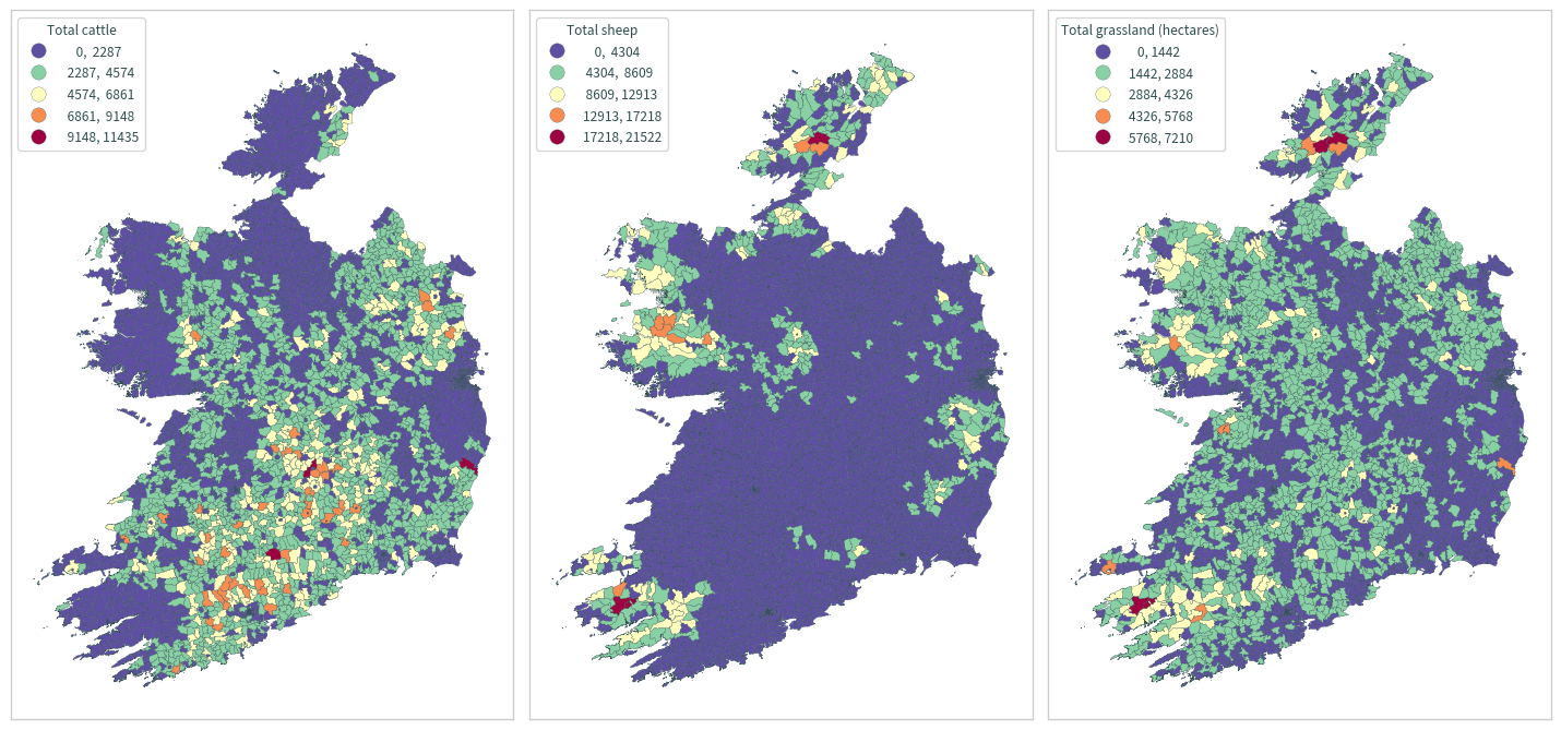
fig, axs = plt.subplots(1, 3, figsize=(15, 15))
cols = [
    ("total_cattle", "Total cattle"),
    ("total_sheep", "Total sheep"),
    ("total_grass_hectares", "Total grassland (hectares)"),
]
for i, ax in enumerate(axs.flat):
    data_ie.plot(
        column=cols[i][0],
        ax=ax,
        cmap="Spectral_r",
        scheme="equal_interval",
        edgecolor="darkslategrey",
        linewidth=0.2,
        legend=True,
        legend_kwds={
            "loc": "upper left",
            "fmt": "{:.0f}",
            "title": cols[i][1],
        },
    )
    # ax.ticklabel_format(style="scientific", scilimits=[-4, 4])
    ax.tick_params(labelbottom=False, labelleft=False)
    for legend_handle in ax.get_legend().legend_handles:
        legend_handle.set_markeredgewidth(0.2)
        legend_handle.set_markeredgecolor("darkslategrey")
plt.tight_layout()
plt.show()
NI data#
bound_ni = gpd.read_file(
    os.path.join("data", "boundaries", "boundaries_all.gpkg"),
    layer="ONS_NI_wards_12_2022_2157",
)
bound_ni.head()
| OBJECTID | WD22CD | WD22NM | WD22NMW | LAD22CD | LAD22NM | BNG_E | BNG_N | LONG | LAT | GlobalID | SHAPE_Leng | SHAPE_Area | geometry | |
|---|---|---|---|---|---|---|---|---|---|---|---|---|---|---|
| 0 | 6905 | N08000101 | Abbey | None | N09000001 | Antrim and Newtownabbey | 148871 | 538433 | -5.89564 | 54.677608 | {5BDA2CD0-D7CB-4D6B-90EB-75F8A1FFD7A4} | 5291.934708 | 9.102273e+05 | POLYGON ((736083.766 883168.756, 736079.853 88... |
| 1 | 6906 | N08000102 | Aldergrove | None | N09000001 | Antrim and Newtownabbey | 123312 | 535417 | -6.28810 | 54.637211 | {EF80E5AC-3B27-4D56-9BB3-0CBFE94D7642} | 66396.070829 | 1.562231e+08 | POLYGON ((716585.770 885559.814, 716589.067 88... |
| 2 | 6907 | N08000103 | Antrim Centre | None | N09000001 | Antrim and Newtownabbey | 126897 | 544127 | -6.24085 | 54.717220 | {2900E2DF-24DB-45B8-8266-663DDF1D3BDF} | 17140.311467 | 1.062755e+07 | POLYGON ((713846.305 888779.215, 713856.936 88... |
| 3 | 6908 | N08000104 | Ballyclare East | None | N09000001 | Antrim and Newtownabbey | 142993 | 547438 | -5.99452 | 54.755379 | {ED83EA03-CE92-4D89-B5C4-BEB02CD9A528} | 8186.240587 | 1.828746e+06 | POLYGON ((728893.847 890935.685, 728892.974 89... |
| 4 | 6909 | N08000105 | Ballyclare West | None | N09000001 | Antrim and Newtownabbey | 141887 | 547417 | -6.01165 | 54.754620 | {0835C4C3-E634-4DEC-B0BE-3A67BFF613C7} | 8307.724846 | 1.782133e+06 | POLYGON ((728672.484 892458.897, 728669.323 89... |
bound_ni.shape
(462, 14)
coa_ni = pd.read_csv(
    os.path.join(
        "data", "agricultural_census", "DAERA", "daera_agricultural_census.csv"
    )
)
coa_ni.head()
| ward_2014_code | ward_2014_name | year | total_grass_hectares | total_cattle | total_sheep | |
|---|---|---|---|---|---|---|
| 0 | N08000101 | Abbey (Antrim and Newtownabbey) | 2018 | 3 | 3 | 3 |
| 1 | N08000102 | Aldergrove | 2018 | 5676 | 10784 | 15053 |
| 2 | N08000103 | Antrim Centre | 2018 | 3 | 3 | 3 |
| 3 | N08000104 | Ballyclare East | 2018 | 3 | 3 | 3 |
| 4 | N08000105 | Ballyclare West | 2018 | 148 | 207 | 152 |
coa_ni.shape
(462, 6)
coa_ni.rename(columns={"ward_2014_code": "WD22CD"}, inplace=True)
data_ni = pd.merge(bound_ni, coa_ni, on=["WD22CD"])
data_ni.head()
| OBJECTID | WD22CD | WD22NM | WD22NMW | LAD22CD | LAD22NM | BNG_E | BNG_N | LONG | LAT | GlobalID | SHAPE_Leng | SHAPE_Area | geometry | ward_2014_name | year | total_grass_hectares | total_cattle | total_sheep | |
|---|---|---|---|---|---|---|---|---|---|---|---|---|---|---|---|---|---|---|---|
| 0 | 6905 | N08000101 | Abbey | None | N09000001 | Antrim and Newtownabbey | 148871 | 538433 | -5.89564 | 54.677608 | {5BDA2CD0-D7CB-4D6B-90EB-75F8A1FFD7A4} | 5291.934708 | 9.102273e+05 | POLYGON ((736083.766 883168.756, 736079.853 88... | Abbey (Antrim and Newtownabbey) | 2018 | 3 | 3 | 3 |
| 1 | 6906 | N08000102 | Aldergrove | None | N09000001 | Antrim and Newtownabbey | 123312 | 535417 | -6.28810 | 54.637211 | {EF80E5AC-3B27-4D56-9BB3-0CBFE94D7642} | 66396.070829 | 1.562231e+08 | POLYGON ((716585.770 885559.814, 716589.067 88... | Aldergrove | 2018 | 5676 | 10784 | 15053 |
| 2 | 6907 | N08000103 | Antrim Centre | None | N09000001 | Antrim and Newtownabbey | 126897 | 544127 | -6.24085 | 54.717220 | {2900E2DF-24DB-45B8-8266-663DDF1D3BDF} | 17140.311467 | 1.062755e+07 | POLYGON ((713846.305 888779.215, 713856.936 88... | Antrim Centre | 2018 | 3 | 3 | 3 |
| 3 | 6908 | N08000104 | Ballyclare East | None | N09000001 | Antrim and Newtownabbey | 142993 | 547438 | -5.99452 | 54.755379 | {ED83EA03-CE92-4D89-B5C4-BEB02CD9A528} | 8186.240587 | 1.828746e+06 | POLYGON ((728893.847 890935.685, 728892.974 89... | Ballyclare East | 2018 | 3 | 3 | 3 |
| 4 | 6909 | N08000105 | Ballyclare West | None | N09000001 | Antrim and Newtownabbey | 141887 | 547417 | -6.01165 | 54.754620 | {0835C4C3-E634-4DEC-B0BE-3A67BFF613C7} | 8307.724846 | 1.782133e+06 | POLYGON ((728672.484 892458.897, 728669.323 89... | Ballyclare West | 2018 | 148 | 207 | 152 |
data_ni.shape
(462, 19)
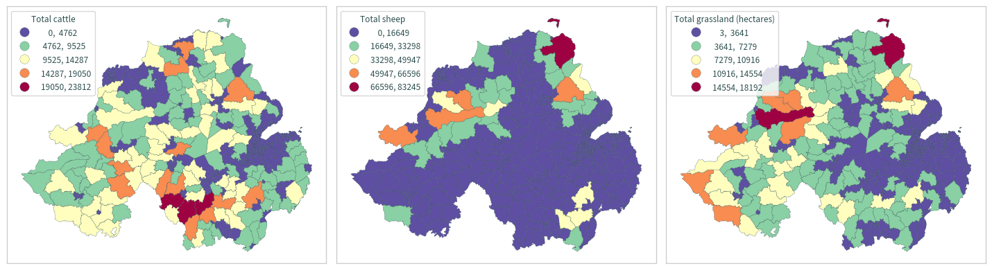
fig, axs = plt.subplots(1, 3, figsize=(15, 15), sharey=True)
cols = [
    ("total_cattle", "Total cattle"),
    ("total_sheep", "Total sheep"),
    ("total_grass_hectares", "Total grassland (hectares)"),
]
for i, ax in enumerate(axs.flat):
    data_ni.plot(
        column=cols[i][0],
        ax=ax,
        cmap="Spectral_r",
        scheme="equal_interval",
        edgecolor="darkslategrey",
        linewidth=0.2,
        legend=True,
        legend_kwds={
            "loc": "upper left",
            "fmt": "{:.0f}",
            "title": cols[i][1],
        },
    )
    # ax.ticklabel_format(style="scientific", scilimits=[-4, 4])
    ax.tick_params(labelbottom=False, labelleft=False)
    for legend_handle in ax.get_legend().legend_handles:
        legend_handle.set_markeredgewidth(0.2)
        legend_handle.set_markeredgecolor("darkslategrey")
plt.tight_layout()
plt.show()
Merge#
# subset data
data_ie = data_ie[
    [
        "ENGLISH",
        "COUNTY",
        "PROVINCE",
        "GUID",
        "total_cattle",
        "total_sheep",
        "total_grass_hectares",
        "electoral_division",
        "geometry",
    ]
]
data_ni = data_ni[
    [
        "WD22CD",
        "WD22NM",
        "ward_2014_name",
        "total_cattle",
        "total_sheep",
        "total_grass_hectares",
        "geometry",
    ]
]
data_ie[["total_cattle", "total_sheep", "total_grass_hectares"]] = data_ie[
    ["total_cattle", "total_sheep", "total_grass_hectares"]
].astype(float)
data_ni[["total_cattle", "total_sheep", "total_grass_hectares"]] = data_ni[
    ["total_cattle", "total_sheep", "total_grass_hectares"]
].astype(float)
/home/nms/miniconda3/envs/ClimAg/lib/python3.10/site-packages/geopandas/geodataframe.py:1472: SettingWithCopyWarning:
A value is trying to be set on a copy of a slice from a DataFrame.
Try using .loc[row_indexer,col_indexer] = value instead

See the caveats in the documentation: https://pandas.pydata.org/pandas-docs/stable/user_guide/indexing.html#returning-a-view-versus-a-copy
  super().__setitem__(key, value)
data_ni["ENGLISH"] = data_ni["WD22NM"].str.upper()
data_ni["PROVINCE"] = "Ulster"
/home/nms/miniconda3/envs/ClimAg/lib/python3.10/site-packages/geopandas/geodataframe.py:1472: SettingWithCopyWarning:
A value is trying to be set on a copy of a slice from a DataFrame.
Try using .loc[row_indexer,col_indexer] = value instead

See the caveats in the documentation: https://pandas.pydata.org/pandas-docs/stable/user_guide/indexing.html#returning-a-view-versus-a-copy
  super().__setitem__(key, value)
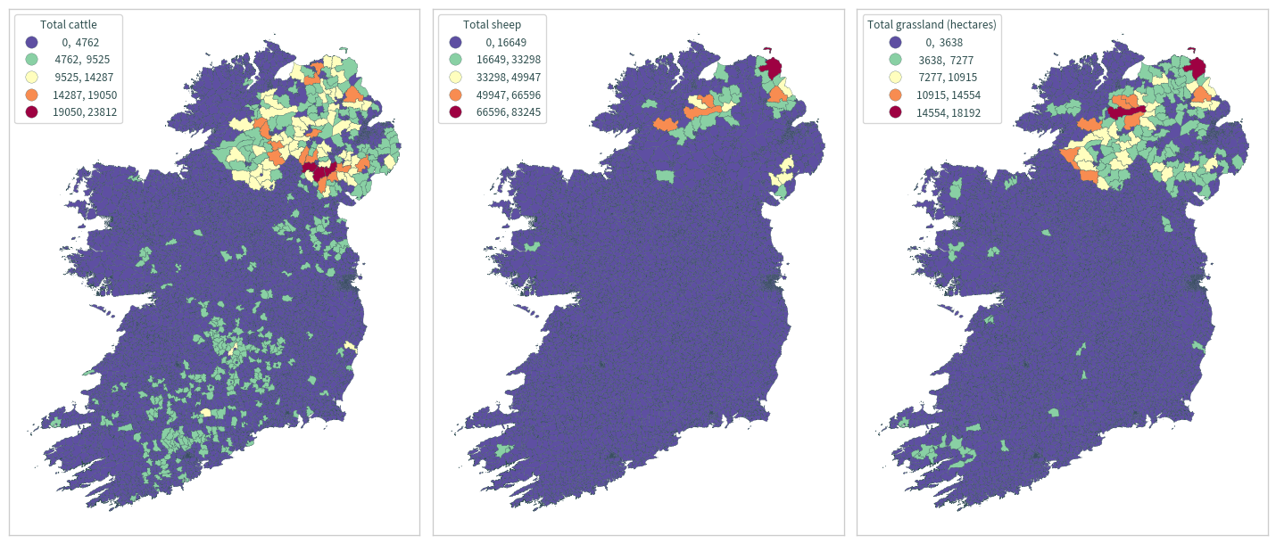
data = pd.merge(data_ie, data_ni, how="outer")
fig, axs = plt.subplots(1, 3, figsize=(15, 15), sharey=True)
cols = [
    ("total_cattle", "Total cattle"),
    ("total_sheep", "Total sheep"),
    ("total_grass_hectares", "Total grassland (hectares)"),
]
for i, ax in enumerate(axs.flat):
    data.plot(
        column=cols[i][0],
        ax=ax,
        cmap="Spectral_r",
        scheme="equal_interval",
        edgecolor="darkslategrey",
        linewidth=0.2,
        legend=True,
        legend_kwds={
            "loc": "upper left",
            "fmt": "{:.0f}",
            "title": cols[i][1],
        },
    )
    # ax.ticklabel_format(style="scientific", scilimits=[-4, 4])
    ax.tick_params(labelbottom=False, labelleft=False)
    for legend_handle in ax.get_legend().legend_handles:
        legend_handle.set_markeredgewidth(0.2)
        legend_handle.set_markeredgecolor("darkslategrey")
plt.tight_layout()
plt.show()
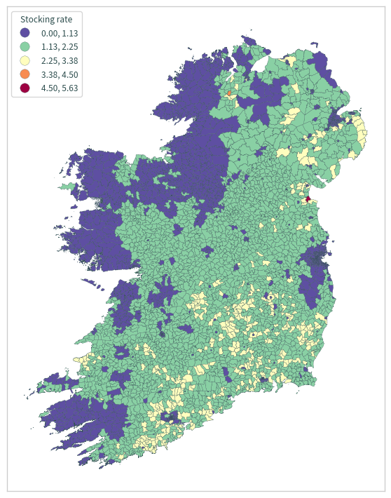
Stocking rate#
data.loc[data["total_grass_hectares"] == 0.0, "stocking_rate"] = 0.0
data.loc[data["total_grass_hectares"] > 0.0, "stocking_rate"] = (
    data["total_cattle"] * 0.8 + data["total_sheep"] * 0.1
) / data["total_grass_hectares"]
data["stocking_rate"].max()
5.627624825011666
data["stocking_rate"].min()
0.0
axs = data.plot(
    column="stocking_rate",
    cmap="Spectral_r",
    scheme="equal_interval",
    edgecolor="darkslategrey",
    linewidth=0.2,
    figsize=(7.5, 7.5),
    legend=True,
    legend_kwds={
        "loc": "upper left",
        "fmt": "{:.2f}",
        "title": "Stocking rate",
    },
)
plt.ticklabel_format(style="scientific", scilimits=[-4, 4])
for legend_handle in axs.get_legend().legend_handles:
    legend_handle.set_markeredgewidth(0.2)
    legend_handle.set_markeredgecolor("darkslategrey")
axs.tick_params(labelbottom=False, labelleft=False)
plt.tight_layout()
plt.show()
data.to_file(
    os.path.join("data", "agricultural_census", "agricultural_census.gpkg"),
    layer="stocking_rate",
)